So, what's the mission then? I've kept it hush until this point, but the idea is to take a mini-satellite up as high into near space as it can go, then release paper airplanes. Below is the approximate mission time and profile.
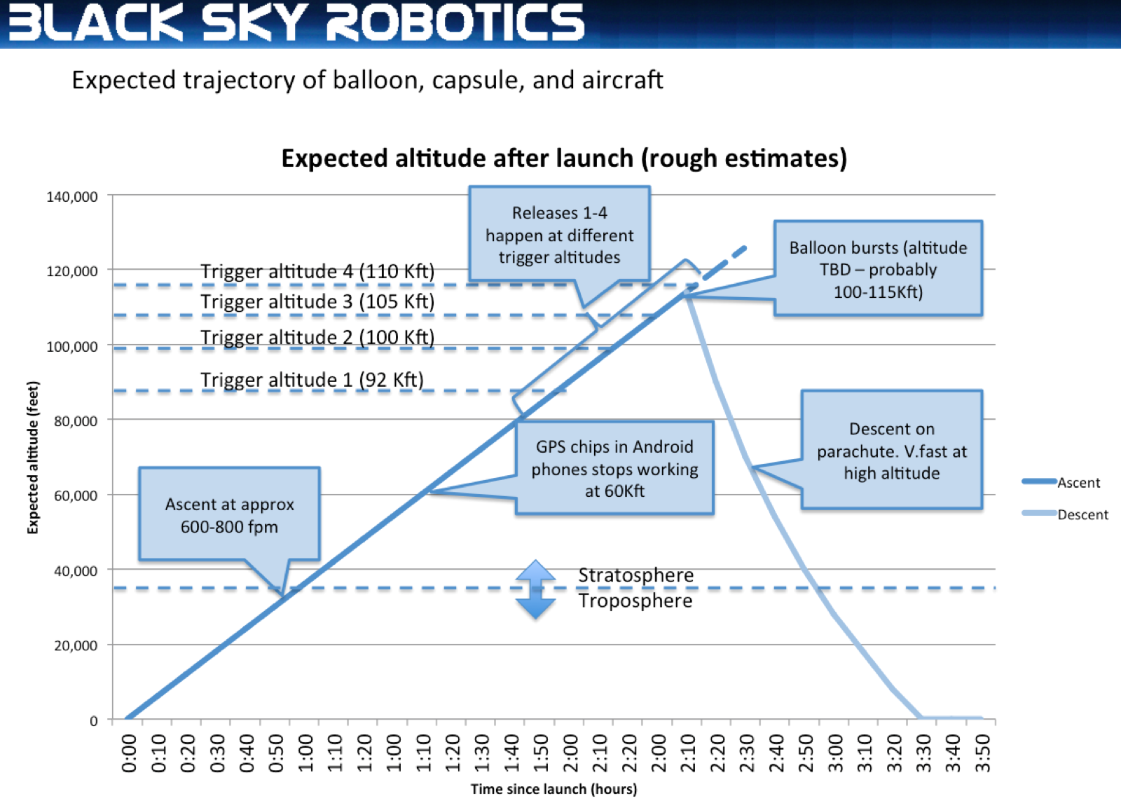
We have a 2000g balloon, which in theory can lift 8-12 lbs to 90-100,000 feet. Our payload is around 3.5 pounds total, so we will underinflate the balloon, so that it lifts the 3.5 pound payload at a reasonable ascent rate, and hopefully bursts at a higher altitude because it can will take longer to stretch to its burst point if underinflated.
We're shooting for a 600-800 feet per minute rate of ascent (which will be monitored remotely), which should mean just over 2 hours to reach burst altitude. Based on other balloon launches, the ascent rate is remarkably constant all the way to about 100,000 feet - the balloon gets bigger as the air gets thinner, and the net effect is that the aerodynamic drag stays about the same.
On the way up, the balloon takes maybe 10-15 minutes to reach 10,000 feet, and around there we lose cellphone coverage until it descends again. The Android phones store any photos, videos and data it takes until it's back in cellphone coverage.
At around 35-40,000 feet the balloon leaves the troposphere, and ascends through the stratosphere. The boundary between the troposphere and stratosphere is where the temperature stops falling, and starts to rise again as the balloon ascends. We have an external temperature sensor that takes readings every two minutes, and it works to minus 40 degrees C, so it should be able to record where this happens.
Above 60,000 feet, the internal GPS chips inside the Android phones stop working and we need to rely on a special GPS chip attached to the robot to know how high up we are. The 60,000 feet limit on GPS chips is an old cold war limit. The US didn't want baddies using cheap commercial GPS chips to guide nuclear missiles (which fly way higher), and most GPS manufacturers still limit their GPS chips to 60,000 feet.
Above 90,000 feet, we have preset "trigger altitudes". The Android phone has a program in it that checks for when the balloon passes a trigger altitude. It then takes a "before release" photo, starts an external video camera (facing down), starts the Android video camera, then releases a bank of paper airplanes, then turns off the video cameras and takes another photo. All of these photos and videos are recorded with the exact GPS coordinates and altitude so we can prove if we get a record or not. There will be 4 banks of paper airplanes, and each bank will have 2-3 planes.
Somewhere between 100 and 115,000 the balloon will get so big that it bursts, and when that happens, the capsule will start falling very quickly. It has a parachute, but the air is so thin up there that the capsule will probably descend at 150-200 mph. Once the Android phones realize that the capsule is descending, it immediately releases a 5th bank of paper airplanes, to try get the maximum altitude for a paper plane launch.
The balloon descends much more quickly than it ascends, but once the air gets thicker below about 30,000 feet, the parachute should slow its rate of descent to about 1500 fpm (feet per minute).
Once the balloon lands, it will keep transmitting files and its location. If it ends up in a swamp, or up a Redwood tree, that means we at least get photos and videos of near space from the Android phone. If we have cellphone reception, I can command it to turn on strobe lights, and to sound a buzzer every 10 seconds so we can find it. If we still haven't found it, and the battery level drops to 25%, it goes into a sleep mode where it shuts down everything else, and only transmits its location every 10 minutes to save batteries. Hopefully we'll find it by then!